
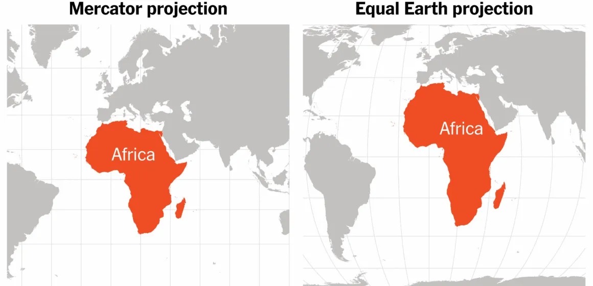
The United Nations General Assembly has backed a move to encourage the use of world maps that more accurately represent the size and proportions of continents, drawing renewed attention to longstanding distortions in conventional maps.
The resolution, approved on Friday, September 4, 2026, by 164 votes to one, with six countries abstaining, encourages governments, educational institutions, international organisations and technology companies to consider adopting more accurate map projections.
The United States was the only country to vote against the resolution, while Estonia, Georgia, Lithuania, Moldova, Serbia and Ukraine abstained.
Although the resolution is not legally binding, it has renewed global discussion about how world maps shape perceptions of geography, particularly the size and significance of Africa and other regions of the Global South.
Much of the debate centres on the Mercator projection, a world map created by Flemish cartographer Gerardus Mercator in 1569.
The projection was designed primarily to support maritime navigation. Its ability to represent lines of constant direction as straight lines made it particularly useful to sailors plotting routes across the oceans.
However, the projection significantly distorts the relative size of land areas, particularly as they become farther from the Equator.
Countries and continents closer to the North and South Poles appear considerably larger than their actual size, while regions around the Equator appear comparatively smaller.
Africa is one of the clearest examples of the distortion. On a Mercator map, Greenland can appear almost comparable in size to Africa, despite Africa being approximately 14 times larger than Greenland in reality.
The distortion has prompted criticism from geographers, educators and advocates who argue that the widespread use of such maps can influence how people perceive the geographical scale and importance of different regions of the world.
The UN resolution encourages consideration of the Equal Earth projection, among other alternatives designed to preserve the relative areas of continents and countries more accurately.
Unlike the Mercator projection, Equal Earth provides a representation of the world’s land masses in proportions much closer to their actual sizes, while maintaining a visually familiar depiction of the continents.
The resolution, however, does not seek to ban the Mercator projection.
Mercator remains useful for certain navigational purposes because of its ability to represent directions consistently. The debate instead focuses on its continued use as a general-purpose representation of the world’s geography, particularly in educational and public contexts.
The move has therefore brought renewed attention to the importance of choosing map projections according to their purpose and to ensuring that representations of the world do not unintentionally distort people’s understanding of the relative size of different regions.
Story by: Hussein Habibata Maltiti
Related Posts